End-to-end utilities engineering with utility design, BIM-GIS integration, and utility infrastructure solutions for smarter project delivery.
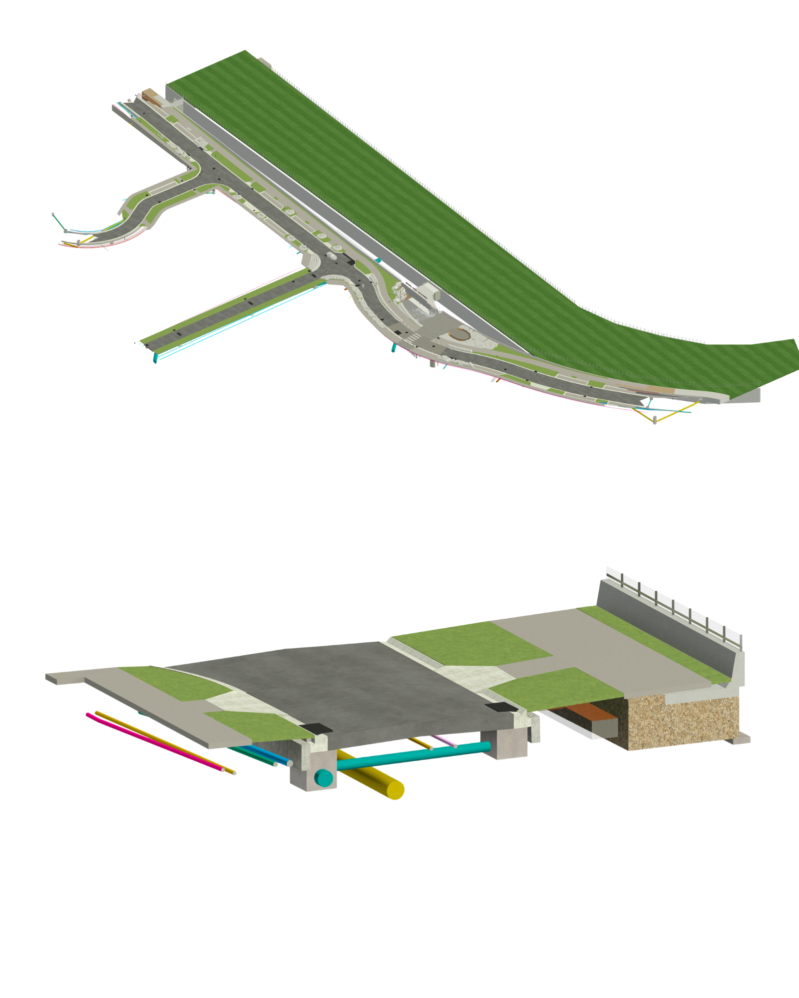
For architects and engineering firms delivering complex infrastructure or urban development projects, utility design is often riddled with fragmented datasets, poor underground visibility, and high clash risks. Manual utilities engineering coordination methods or isolated GIS data lead to avoidable site delays, design revisions, and regulatory issues. The burden of staffing domain experts for every location adds to both cost and risk. Project stakeholders face mounting pressure to deliver accurate and efficient utility infrastructure solutions while navigating growing environmental and compliance challenges.
Moreover, the lack of unified models between infrastructure designers and MEP engineers further exacerbates communication gaps, resulting in missed opportunities for sustainability, BIM GIS integration, smart city planning, and reduced lifecycle costs. Clients today demand faster, technology-driven, and scalable solutions.
Our Integrated Utilities Engineering (M&E) Solutions
Model subsurface utility layouts in BIM for visibility, clash detection & risk mitigation.
Cross-discipline coordination of all utilities across design and construction phases.
Merge geospatial data with BIM for location accuracy, asset mapping & planning insights.
Our professionals bring expertise in leading digital tools. Tools are procured per project needs, ensuring agile and cost-effective delivery.

At DGTRA, we don’t just support; we partner. We bring technology fluency, ISO 19650-led standards, and proven utility coordination experience.
Our data-centric workflows, secure environments, and proactive project ownership set us apart. From managing M&E conflicts to scaling your internal team with certified specialists, our goal is to ensure your design-build process flows uninterrupted.
Talk to us today about your underground utility modeling needs.
Yes. We combine GIS datasets with BIM to support spatial planning, asset visibility, and regulatory compliance.
Autodesk Civil 3D, Revit, Navisworks, Plant 3D, ArcGIS, QGIS, Bentley OpenUtilities, and more.
We offer complete services from modeling to cross-disciplinary coordination and clash detection.
Yes. We integrate seamlessly with internal teams and help scale your utility design processes.
Yes. We follow ISO 19650 principles and have internal data protection policies across all delivery centers.
DGTRA acts as a System Integration and Consulting Partner to several large Real Estate, Construction, Infrastructure and Manufacturing companies in India, US, UK and Australia. Our vision is to get established as a change agent, a catalyst that triggers the process of Digital transformation within an organization enhancing overall project and Business efficiency.
DGTRA © 2025 All Right Reserved .
Our team is here to help you!

We use cookies to improve your experience on our site. By using our site, you consent to cookies.
Websites store cookies to enhance functionality and personalise your experience. You can manage your preferences, but blocking some cookies may impact site performance and services.
Essential cookies enable basic functions and are necessary for the proper function of the website.
These cookies are needed for adding comments on this website.
Google Tag Manager simplifies the management of marketing tags on your website without code changes.
Statistics cookies collect information anonymously. This information helps us understand how visitors use our website.
Google Analytics is a powerful tool that tracks and analyzes website traffic for informed marketing decisions.
Service URL: policies.google.com
You can find more information in our Cookie Policy and Cookie Policy.